Italy: Lake Garda - The wind and weather conditions
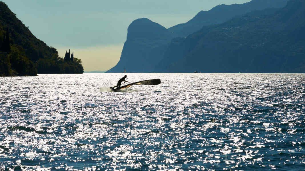
Everything used to be better. Yawn! But because surf readers keep telling us that in the surfing Mecca of the south, Lake Garda, the thermals are increasingly running out of steam, we set out on a search and did some research. Is there anything to it? Or is it a typical case of subjective perception? We got answers from Klaus Reitberger, a Lake Garda surfer from the very beginning and operator of the website www.windinfo.eu which specialises in wind forecasts for numerous Alpine lakes. Klaus Reitberger is, as he emphasises, not a trained meteorologist, but has been involved with the subject since time immemorial and knows the very special wind conditions on the lake not only from theory. He operates a webcam on the pier and a weather station on the Conca d'Oro and, thanks to 37 years of experience on the lake, can also link this data with practical experience on the water. We asked him for an interview.
Klaus, there are many surfers on Lake Garda who claim that the thermals are getting worse and worse. What's the truth in that? In general, you first have to understand why thermals are created in the mountains in the first place: I always compare it to two glass boxes. The first is in the foothills of the Alps, whether in the south or north, and is 100 per cent filled with air. The second glass box is placed over the mountains. Both boxes have the same volume, but in the Alps the mountains take up a lot of space, so only part of the glass box is filled with air. This means that less air mass has to be heated in the mountains for the same amount of energy from the sun. As a result, the air in the Alps warms up faster than in the Alpine foothills, the warmer air now begins to rise (falling air pressure, also known as a heat low), while the air pressure is higher in the Alpine foothills. This results in an exchange of air masses, from higher pressure to lower pressure. On the north side of the Alps this happens from north to south, on the south side from south to north. This is the south wind on the lake that everyone knows.
What other factors make Lake Garda so special? In principle, the lake is ingeniously orientated. The valley is open on both sides, reaches far up to the Brenner Pass and is orientated exactly north-south, which means that the wind is not blocked and a long suction channel is created. Added to this is the narrowing in the northern part of the lake, where the wind is channelled and amplified (Venturi effect). The fact that the lake is only 60 metres above sea level, despite the high mountains all around, also has a positive effect, as there is a thick layer of air above it that can rise higher into the Alps when it warms up. Other lakes in the Alps, such as Lake Silvaplana at over 1700 metres above sea level, have poorer conditions here - which is another reason why the thermals are usually weaker there.
Back to the initial question: Have the thermals got worse? Yes, that is certainly true overall! And there are many different reasons for this that add up.
Which ones? The first factor is climate change. In our mid-latitudes, this is having an impact in that we generally have higher temperatures, both in summer and in winter. During the summer months, it is now significantly warmer at higher altitudes than it used to be. You can see from the melting of the glaciers, for example, that the zero-degree limit continues to rise. For lake thermals, this means that it cools down significantly less at night and the temperature differences during the day (day/night difference) are smaller. And it is precisely this difference that is needed to generate good thermals!
So the assumption "warm = strong thermals" is actually rubbish? Exactly! Even if there are many other factors that influence thermals (e.g. the influence of foehns or frontal systems), one of the most important factors is the temperature difference. If it is cold at night and it warms up quickly and very strongly in the morning, there are great thermals. If, on the other hand, it stays warm at night until well up - which is often the case in summer, or if clouds cover the system at the top - the temperature difference towards midday is only slight. Then the thermals are also weak. In summer, the zero-degree limit is now often at 4000 metres and above, but good thermals are more likely to be found at 2500 to 3000 metres.
This also means that summer can't be the time with the best thermals, right? It has always been a fairy tale that the best thermals are in summer! Even 30 years ago, the strongest ora was in spring, when the nights are still cold and the sun is high during the day and already has a lot of power. Many holiday surfers think: "High summer is in August, it's hot and that's when the best thermals are". However, people often forget that the sun is at its highest in our latitudes in mid-June. This means that the position of the sun in mid-August is the same as in mid-April, only in August the water of the lake is a warm bathtub and the nights are mild. In April, on the other hand, hardly anyone goes swimming without a wetsuit or is still sitting in a T-shirt and board shorts at the wind bar at midnight! However, the general weather situation in spring is often still changeable and there are always fronts coming in that kill the thermals (e.g. north foehn). In my experience, the period with the strongest thermals is between March and the end of May. Although the wind blows more frequently in summer because the general weather situation is more stable then, the thermals are much weaker overall.
Are all thermal spots in the Alps affected by the consequences of climate change? Yes, in principle this applies to all thermal spots in the mountains, not just the Lago. But there are also other factors.
Which ones? The higher temperatures also change the vegetation. Studies by the University of Innsbruck have shown that the increase in temperature in alpine areas is above average, which also causes the tree line to rise. In pre-industrial times, for example, this was just under 2200 metres in the Tyrolean Alps; today, young growth can be found at altitudes of 2370 metres. Because vegetation always cools and heats up less than bare rock, the thermals are also reduced. In addition, agriculture is practised more intensively today, meaning that significantly more land is utilised, even at high altitudes. South Tyrol and Trentino are the largest fruit producers in Italy, which was significantly less 30 years ago, not to mention the wine-growing areas. All in all, there is more and more greenery up to high altitudes, which doesn't really help the thermals.
All in all, when is the best time of year for a trip to the lake? There is also the north wind... Autumn is traditionally the time with the best north wind. If there are cold spells in the mountains or even fresh snow, you can blindly get in the car and set up your 4-person sail in Al Pra - the wind is guaranteed to come! If you don't live "round the corner" and have to plan well in advance, you're on the better side in terms of wind frequency in July and August. Our statistics for these months show around 23 days with morning northerly winds and around 26 days with Ora from midday - only that these are less strong, blow over a shorter period of time and you sail larger sails. However, you can get more out of Ora if you know where it blows strongest during the course of the day.
What tips do you have in this regard? At midday, when the Ora sets in, it's better on the pier and Ponale (west bank, near Riva, the ed.) because this mountain flank is already warmed up all morning and the air rises there earlier. In the afternoon, the east side near Torbole and the Conca d'Oro is lit up, then the wind field shifts in this direction, which is why you always have a bit more fun here than on the west side. I recommend being flexible and changing sides with the position of the sun, so always surf downwind of the sun. And ultimately, of course, today's better equipment also helps to compensate for the wind disadvantage. In this respect, I am optimistic that we will still be having fun here in 20 years' time.
How the Lago wind system worksMountain and valley wind The wind conditions at Lake Garda are prototypical for the mountain and valley wind system. The thermal Ora from the south arises because a smaller volume of air has to be heated in the Alps compared to the Alpine foothills. As a result, the air tends to rise over the main Alpine ridge due to solar radiation, creating a so-called heat low. (Fig. 1 & 2 below)
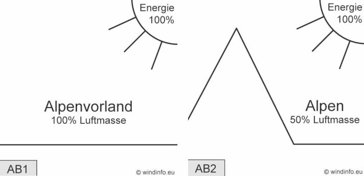
Because air masses always flow from high to low air pressure, an equalising movement is set in motion from the Alpine foothills to the main Alpine ridge, the valley wind (bottom left). South of the Alps, the air thus flows from south to north; on the northern side of the Alps, the air flows from north to south. The greater the temperature differences during the day (day/night), the faster and higher the warming air masses rise and the greater the resulting suction - strong Ora on the lake is the result.

At night, the system reverses - the smaller volume of air over the Alps cools down faster than that in the Alpine foothills, causing air masses to sink over the Alps. This results in an overpressure on the ground, a so-called "cold high", which causes cool air masses to flow from the Alps into the Alpine foothills (mountain wind, top right) - this is the north wind on the lake known as the "Peler". The fact that the north wind is often referred to as "Vento" is actually completely nonsensical. "Vento" means nothing other than "wind" - the thermal Ora is therefore also a "vento".
Local Venturi effects While the mountain and valley wind system represents the overarching, large-scale system, the special natural conditions at Lake Garda also provide localised amplification. Wherever there are constrictions due to mountain flanks and rocky outcrops, the wind is accelerated, similar to a garden hose that is compressed at the front. In northerly winds, this Venturi effect is noticeable in Malcesine (bus car park), at the pier or further south around Campione (bottom right) and Al Pra.
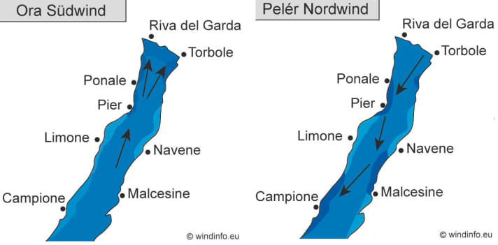
South winds (Ora), on the other hand, are noticeably stronger further north at Hotel Pier, Ponale (top left) and Conca d'Oro. However, it should be noted that the Ora wind field shifts with the position of the sun: the thermals are always strongest on the side of the lake that is more strongly illuminated by the sun. When the Ora starts, this is the western side between the pier and Riva (Ponale), and in the late afternoon the eastern side in front of Torbole and the Conca d'Oro.
